|
|||
|
|
|||
|
|
|||||
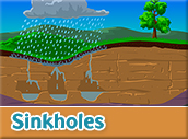
Karst topography is a landscape created by groundwater dissolving sedimentary rock such as limestone. This creates land forms such as shafts, tunnels, caves, and sinkholes. Groundwater seeps into and through these land forms. The result is a scenic landscape which is beautiful but fragile, and vulnerable to erosion and pollution.
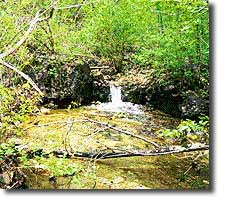
Springs: Natural resurgence, or discharge, of groundwater from rock or soil to the surface. Caves: Natural cavities beneath the surface of the earth, created by groundwater dissolving rock. Sinkholes: Rounded depressions in the landscape. Sinkholes are often collapsed caves and can be quite deep, or they can be shallow holes. Sinkholes collect surface water running off the surrounding land, and the runoff goes directly into the groundwater. Losing Streams: Losing streams, or sinking streams, lose part or all of their flow to the groundwater system by suddenly disappearing underground. Bryant Creek is a losing stream, typical of the karst topography found in the Ozarks. Natural bridges: Arches that are the remnants of collapsed caves, usually fairly short. Seeps: Slow, small discharges of water from rock or soil to the surface. Karst in the Watershed From the Karst Series in the West Plains Daily Quill. Part 1 presents an overview of water movement in the region's karst topography, and looks at the dye tracings which help locate the recharge areas for springs. Part 2 presents discoveries on why groundwater becomes cloudy at times, and the connection to our drinking water. Lots of information on losing streams, springs and sinkholes. Streamflow
between Bryant and North Fork: |
|
||||