watersheds.org the world in your watershed search
homeOnline Casinowhat's newabout ussite mapcontact us
 

Places What is a Watershed? The Ozark Divide
 

THE OZARK DIVIDE

A Tale of Two Raindrops


Watersheds of the Mississippi River Basin
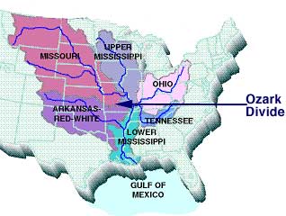
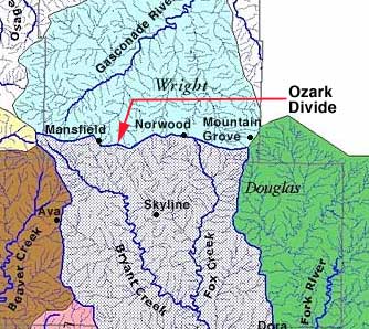
Imagine two raindrops falling from the clouds to land side by side, only inches apart, on the Ozark Divide. 

One, by chance, falls just to the south of the very top of the ridge. The other falls just across the ridgetop, to the north. 

They will not meet again for many days and then after a journey of over a thousand miles. Though they began their journey only inches apart, they have not only fallen into different watersheds; they have fallen into different river basins. 

The White River Basin

One has fallen into the White River Basin, and will travel south, down the Bryant into the North Fork of the White River, then into the White River. The White River empties into the Mississippi River in Arkansas. 

The Missouri River Basin

The other raindrop, which fell on the north side of the ridge, has landed within the Missouri River Basin. It will travel north through the Gasconade River watershed, some 300 miles to the Missouri River. The Missouri River empties into the Mississippi near St. Louis, Missouri. 


Gasconade and Bryant watersheds, on either side of the Ozark Divide, in two different river basins.
Down the Mississippi to the Gulf of Mexico

The two raindrops may meet again only when the Mississippi River finally empties all the watersheds in its range into the Gulf of Mexico southeast of New Orleans, LA. There, the silt and sand from our local watersheds mixes with the snowmelt of Wyoming and North Dakota, the melted hailstones of Kansas and Nebraska, and the runoff from farms in Ohio, Tennessee, Mississippi, Iowa, Wisconsin and many other states. 


Written for the Atlas by Marideth Sisco. Maps: Mississippi River Basin map courtesy of EPA. Local watersheds map by Mike Dickerson, SMSU Bull Shoals Field Station.

Top