|  
Places  Local Watersheds Finley River Watershed Local Watersheds Finley River Watershed
Finley River Watershed 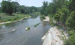 |
The Finley River is a gentle stream flowing through rolling hills and pastureland. It was easily harnessed to provide for the needs of early European settlers. Before that, it was a highway for Native American travelers. | | Finley River, a tributary of the James River, gets its start in the high land around Cedar Gap. Its headwaters are about 3.5 miles west of the headwaters of Bryant Creek. It flows east to west for a distance of 52.8 miles. Though it starts in Webster County, 48 miles of its length are in Christian County. The final 3 miles are in the northeast corner of Stone County. Only the last 19 miles are floatable in high or medium-high water. The floatable part begins at a put-in at Linden and ends where it meets the James River. The Finley Watershed is long and narrow, with a total area of about 269 square miles, most of it open grassland. The balance is forested. Ozark, county seat of Christian County, with a population of about 10,000, is the only large town in the watershed. Sparta, with a population of around 1,000, is the only other town of any size in the watershed. | 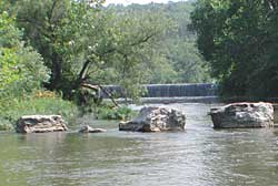 | Looking upstream from the Linden put-in, the dam shown contains Lindenlure Lake, a popular local swimming area. The lake began as a millpond, but the mill is long gone, replaced by a private resort community that has provided summer vacationing for local families for decades. From here, you can float Finley Creek to its confluence with James River. | 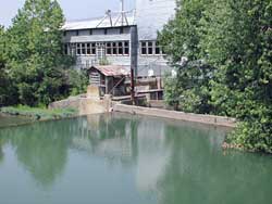 | A mill and its millpond and dam in the heart of Ozark, MO. Finley Creek was the engine that powered the mill, which is still in working condition. | 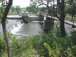 | Six miles downstream from Ozark, another dam and powerplant is a landmark for summertime swimmers as it crosses the Finley below Riverdale Dam. This powerplant is modern, and was built to produce electricity. | 
Sources: Missouri Atlas and Gazetteer, DeLorme, Yarmouth, Maine, 1998, pages 62, 63.
Missouri Ozark Waterways,Oz Hawksley, Missouri Department of Conservation, Jefferson City, 1997.
Missouri Resource Assessment Partnership, Land Cover by Hydrologic Unit.
Missouri County Fact Sheets, Evelyn Cleveland, MU Outreach and Extension, 1999.
|