| |||
| | |||
|
Bryant Spring can be found near the Headwaters area of the Bryant Watershed, about six miles north of Ava and just west of Highway 5. The flow from Bryant Spring marks the beginning of the Bryant as a perennial (always flowing) stream. The spring is small compared to the other major springs in the watershed. Its average flow is around 1.1 cfs (cubic feet per second), or 711,000 gallons a day. That was enough, however, to power a grist mill in years past.
Crystal Spring flows near Hunter Creek, six miles east of Ava. It flows from beneath a ledge of Roubidoux sandstone at an altitude of 920 feet. It is the highest spring in the North Fork basin, with flow above 10 cubic feet per second. Its flow is around 12.7 cfs, or 8,190,000 gallons a day. The spring opening is in a pool formed by a dam. The spring was formerly the power source for an ice plant and lights for a nearby resort. Today, Crystal Spring is a commercial hatchery and fishing spot. Fish raised at the hatchery were shipped to the 1963 World's Fair.
Most sources say this is the 15th largest spring in Missouri. (One source, the beautiful and informative Springs of Missouri website, says the spring is the 19th largest.) This is the site of the famous Hodgson Mill, where Highway 181 crosses the Bryant. The spring opening is a joint in dolomite and sandstone situated at the base of a high Roubidoux sandstone bluff. Over thousands of years, the flow of water has dissolved the rock and enlarged the opening. The old mill is built over the spring opening so that part of the water is channeled under the mill to the water wheel. The rest of the water enters a pool, then rushes over a dam into the spring branch. The branch runs 600 feet into the Bryant. Average flow is 36.4 cfs, or 23.5 million gallons a day.
These springs are located in and near Spring Creek at Rockbridge, just off Highway N. Rockbridge Spring is actually four springs rising in the lake formed by the old mill dam. Nearby, Morris Spring flows from an opening along a bedding plane in dolomite near the contact between the Gasconade Dolomite and the overlying Roubidoux sandstone. There it forms a small pool. The flow of Rockbridge spring is about 19.1 cfs, or 12,345,000 gallons a day. Morris Spring flows about 3.6 cfs, or 2,335,000 gallons a day. The old mill still stands at the site of the old town of Rockbridge, the first Ozark County seat.
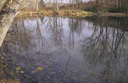
Zanoni Spring
Sources: Springs of Missouri,1974; Surface Water Resources of Missouri, James Van Dyke, Missouri Department of Natural Resources, 1995. |