|
|||
|
|
|||
 
Watersheds |
||||||||||||||
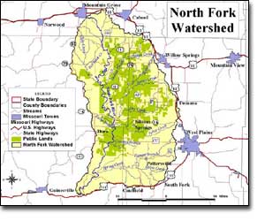
North Fork Watershed |
||||||||||||||
You can float the North Fork of the White River for 49.5 miles, from the Hwy. 76 bridge about 12 miles west of Willow Springs, to the Hwy.160 bridge at Tecumseh. The North Fork's total length, from its source just south of Mountain Grove in Wright County, to Tecumseh, in Ozark County, is about 62 miles. The North Fork and Bryant watersheds are almost the same size. The North Fork's area is 571 square miles, and the Bryant's is 584. But, strangely, the North Fork's flow is about 50% greater. It doesn't get any more rain, so how can this happen? Stream flow studies have discovered that part of the Bryant's flow is diverted into underground streams that siphon water from Bryant Creek and empty it into the North Fork River. This extra water makes the North Fork a much more popular floating stream. Henry Rowe Schoolcraft and his companion, Levi Pettibone, traveled nearly the entire length of the North Fork River in 1818. Schoolcraft's journals provide the best early historical account of what types of land cover once existed within the North Fork watershed. Land use/land cover within the North Fork watershed today primarily consists of grassland/cropland and forest/woodland. About 13.1% of the watershed is in public ownership; most of which is managed by the United States Forest Service as part of Mark Twain National Forest. The only water control structure on the North Fork River in Missouri is Dawt Mill Dam. This is a relatively low structure (less than eight feet high) located approximately 1.8 mile above Tecumseh Missouri. North Fork Conservation Opportunity Area The Missouri Department of Conservation has joined with
partners to take an “all wildlife conservation” approach. Conservation
Opportunity Areas (COA) are priority places for all wildlife conservation.
Each Conservation Opportunity Area has a stakeholder team that determines
goals and conservation actions. They also have resources available for
public and private landowners interested in joining their local efforts. |
|
|||||||||||||
| Sources:
North
Fork WATERSHED INVENTORY AND ASSESSMENT Sources: Missouri Atlas and Gazetteer, DeLorme, Yarmouth, Maine, 1998, pages 63, 64. Missouri Ozark Waterways,Oz Hawksley, Missouri Department of Conservation, Jefferson City, 1997. Missouri Resource Assessment Partnership, Land Cover by Hydrologic Unit. Missouri County Fact Sheets, Evelyn Cleveland, MU Outreach and Extension, 1999.  The
development of content for *Our Watersheds Our Homes* is funded in part
by the U.S. Environmental Protection Agency Region 7, through the Missouri
Department of Natural Resources, under Section 319 of the Clean Water Act.
DNR Subgrant #G04-NPS-17. The
development of content for *Our Watersheds Our Homes* is funded in part
by the U.S. Environmental Protection Agency Region 7, through the Missouri
Department of Natural Resources, under Section 319 of the Clean Water Act.
DNR Subgrant #G04-NPS-17.
|
||||||||||||||