|
|||
|
|
|||
 
Watersheds |
||||||||||||||||||
Spring River Tributaries Watershed |
||||||||||||||||||
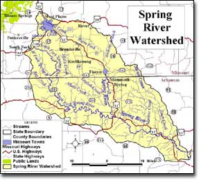
The Spring River Tributaries Watershed covers about 480 square miles in Missouri, within parts of Howell and Oregon Counties, or about 40% of the total area of the Spring River Watershed, the remainder being in Arkansas.
The two most prominent natural features in the watershed are Grand Gulf (Missouri) and Mammoth Spring (Arkansas). Land use/land cover within the Spring River Tributaries Watershed primarily consists of grassland/cropland (49.1%) and forest/woodland (48.3%). Urban areas make up 2.4% of the watershed. The watershed has two urban areas with a population of over 1,000 persons. These are Thayer (population 1,996) and West Plains (population 10,913). West Plains is the largest population center in South Central Missouri. It is also a hub of transportation. Two U.S. highways and one rail line intersect the city of West Plains and thus the watershed. The population density of the watershed is approximately 43 persons per square mile. Approximately 2% of the watershed is in public ownership, nearly all of which is managed by the Missouri Department of Conservation. The largest public area is the 6,579 acre White Ranch Conservation Area. Other public areas include Grand Gulf and Tingler Prairie. |
|
|||||||||||||||||
| Sources:
Spring
River Tributaries WATERSHED INVENTORY AND ASSESSMENT Missouri Regional Social and Economic Profile  The
development of content for *Our Watersheds Our Homes* is funded in part
by the U.S. Environmental Protection Agency Region 7, through the Missouri
Department of Natural Resources, under Section 319 of the Clean Water Act.
DNR Subgrant #G04-NPS-17. The
development of content for *Our Watersheds Our Homes* is funded in part
by the U.S. Environmental Protection Agency Region 7, through the Missouri
Department of Natural Resources, under Section 319 of the Clean Water Act.
DNR Subgrant #G04-NPS-17.
|
||||||||||||||||||